
At a Glance
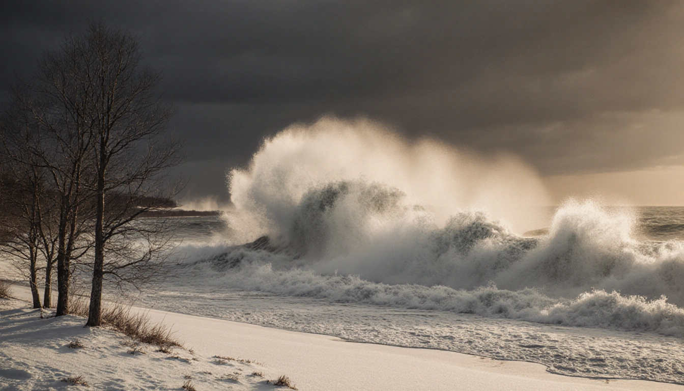
- A bomb cyclone slammed the Midwest Monday, unleashing blizzards, power outages and a 20-foot wave on Lake Superior.
- Nearly 220,000 customers lost power nationwide, with a third in Michigan.
- Strong winds and a wintry mix also rattled the Northeast, West Coast and Alaska.
- Why it matters: Millions of travelers faced delays, power outages and hazardous conditions across the country.
A rapid-strengthening bomb cyclone slammed the northern United States Monday, unleashing blizzards, treacherous travel and power outages across the Plains and Great Lakes.
Storm Overview
The storm intensified quickly enough to meet the criteria of a bomb cyclone. A sharp cold front left parts of the central U.S. waking up Monday to temperatures as much as 50 °F colder than the day before. Dangerous wind chills plunged as low as -30 °F across parts of North Dakota and Minnesota.
Cody Snell said:
> “a pretty significant system for even this part of the country”
Forecasters expect the storm to intensify, fueled by a clash between frigid Canadian air and lingering warmth across the southern United States.
Impact on the Midwest and Great Lakes
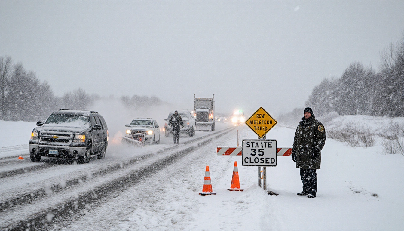
In Iowa, blizzard conditions eased by Monday morning but high winds were still blowing fallen snow across roadways, keeping more than 200 miles of Interstate 35 closed. State troopers reported dozens of crashes, including one that killed a person.
| Region | Power Outages | Flight Delays | Flight Cancellations |
|---|---|---|---|
| Nationwide | ~220,000 | >9,000 | 889 |
| Michigan | >1/3 of outages | ||
| Upstate NY | >57,000 |
Nearly 220,000 customers were without power Monday night, more than a third in Michigan, according to News Of Austin. Airports reported over 9,000 flight delays and 889 cancellations.
Snow piled up quickly in Michigan’s Upper Peninsula, where as much as 2 ft fell in some areas, according to the National Weather Service. Meteorologist Ryan Metzger said additional snow was expected in the coming days, although totals would be far lighter.
Lake Superior and Erie Effects
Waves on Lake Superior were expected to reach 20 ft Monday, sending all but one cargo ship into harbor for shelter, according to News Of Austin. Weather forecasting on the lakes has improved greatly since the Edmund Fitzgerald sank in 1975 after waves were predicted at up to 16 ft.
The fierce winds on Lake Erie sent water surging toward the basin’s eastern end near Buffalo, New York, while lowering water on the western side in Michigan to expose normally submerged lakebed – even the wreck of a car and a snowmobile.
Kevin Aldrich, 33, a maintenance worker from Monroe, Michigan, posted photos of wooden pilings. He said:
> “Where those are at would typically be probably 12 feet (3.6 meters) deep. We can usually drive our boat over them.”
On the New York side, the National Weather Service said lake levels had risen to just below 8 ft, with the potential to reach 9 ft or more by late Monday, due to the strong southwest wind flow. The agency also predicted significant lakeshore flooding along the Lake Erie shoreline of Erie and Chautauqua counties as well as along the upper Niagara River.
Other Regions Affected
Rain and a wintry mix fell farther east across parts of the Northeast. Freezing rain was reported in northern New York, with the threat extending into Vermont, New Hampshire and Maine. Forecasters warned the ice and wind could strain power lines and trees. Heavy lake-effect snow and possible whiteouts were forecast Tuesday for the northwestern part of the state.
On the West Coast, the National Weather Service warned that moderate to strong Santa Ana winds were expected in parts of Southern California through Tuesday, raising concerns about downed trees. Two more storms were forecast later this week, with rain on New Year’s Day potentially soaking the Rose Parade in Pasadena for the first time in about two decades.
A weekend snowstorm hit Alaska’s northern panhandle with 15-40 in (38-102 cm), according to the National Weather Service, keeping the region under a winter storm warning Monday as Juneau braced for up to 9 in (23 cm) and possible freezing rain. City facilities were closed and road crews piled snow into towering berms, while communities farther south faced flood watches from snowmelt and heavy rain.
In central and eastern Illinois, the National Weather Service confirmed three tornadoes on Sunday, including an EF1 tornado with peak winds of 98 mph that damaged buildings and snapped power poles.
Key Takeaways
- A bomb cyclone slammed the Midwest, causing blizzards, power outages and a 20-foot wave on Lake Superior.
- Nearly 220,000 customers lost power nationwide, with a third in Michigan.
- Strong winds, ice, and wintry mix rattled the Northeast, West Coast, Alaska and even produced tornadoes in Illinois.
The storm’s rapid intensification and widespread impacts underscore the growing volatility of winter weather across the United States.
Contributed by Aiden V. Crossfield